
DIGITAL MODELS FOR WIRELESS NETWORK PLANNING AND OPTIMIZATION
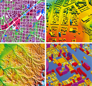 Proprietary data processing software and cutting-edge technology ensure our customers of the highest quality databases for wireless networks design
We provide our clients with optimal solutions fitted to their projects including:
- Regional planning
- Urban planning
- Microplanning (3D models)
Resolutions: from 100 m to 2 m
Layers available: DTM, DEM, Land Use Maps (Clutter), Vectors, Text labels,
Building Heights Model, Orthoimage, Rastermap
Data format: all major RF planning systems and GIS formats